Mount Damāvand
Geography
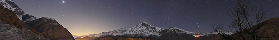
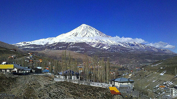
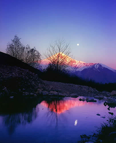
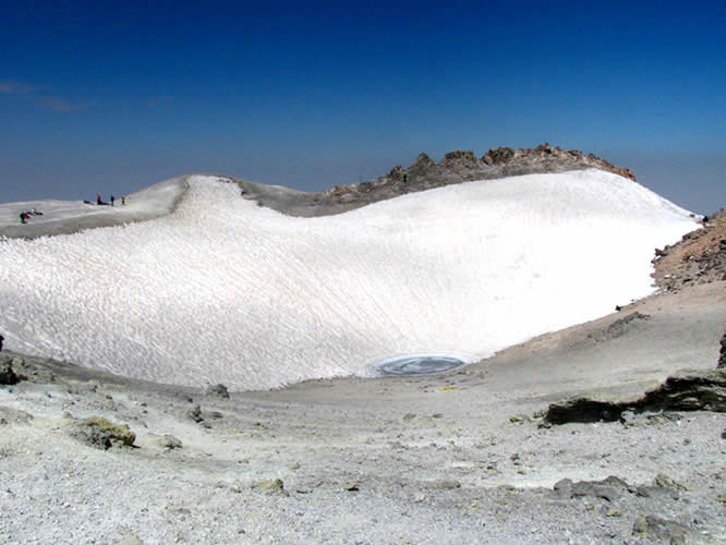
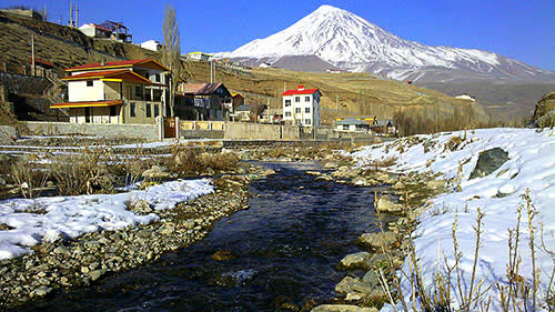
Damāvand is situated in the high Harāz valley of Māzandarān, on a line with the crests of the central Alborz, the peaks of which do not exceed 3,800 m. It is a small volcanic structure only 400 km2 at its base but owing its extreme elevation to an underlying foundation rising as high as 2,400 m on the side toward Polūr and an additional 1,400 m higher because of the northern lava flows below Ḥājī Delā, for a total of more than 4,000 m (Geological Survey; sheet “Damāvand”). The volcano itself is fairly regular but not symmetrical. The customary ascent is from the village of Reyna, traversing the comparatively gentle southern slope. There is a shelter in the village and another at an altitude of 4,250 m. The northern side is more inhospitable, with several glaciers on the east and northeast among the rocky arêtes that form the broad Lāndal (or Nāndal) basin; several high-altitude shelters have also been constructed for climbers on that side. To the west and south, in the valleys of the Dalī Čāy, Lār, and Harāz rivers, a series of lava flows and folds (šāl) have resulted in an often chaotic kind of plateau topography. The streams, especially the Harāz (known as the Lār above Polūr), which flows around the volcano, play a particularly important role in the morphology of the southern slope of Damāvand. Lava flows have cut the Lār valley and provided the foundation for successive sedimentary deposits that have created broad plains on the interior of the mountain, whereas farther downstream, to the east, the Harāz has hollowed out an enclosed valley in the soft terrain of lias and volcanic ash.
The base of the volcano rests unevenly on a very folded geological substratum of compacted sediments, clays, and often unstable schists composed of lias and resistant Jurassic and Cretaceous limestones. The volcano overlaps the green rocks of the Karaj formation (Tertiary) only north of Lāndal. Volcanic rock has thus enveloped and preserved the very different type of mountain relief that characterized the central Alborz at the beginning of the Pleistocene. The volcanic mate¬rial, the earliest components of which are alkaline and those from more recent eras acidic, is composed mainly of trachyandesite, andesite, and various types of breccia originating in volcanic eruptions, which also pro¬duced ashes and glassy formations; the latter are routinely exploited. The formation of the volcano by lava flows and emission of ashes lasted, with intermittent periods of dormancy, from the end of the Pliocene to the Holocene, that is, to the end of the Neolithic era. At present volcanic activity is manifest only in the presence of warm springs, which have formed travertine deposits, especially in the Harāz valley, where there are also many small geysers near the hot sulfur springs of Ask and Āb-e Garm, which have been in use since antiquity and remain very popular. Close to the summit volcanic emissions have produced sulfur deposits, which were exploited by inhabitants of the region until the beginning of this century. This volcano is one of the manifestations, rather than the cause, of strong seismic forces in the central Alborz, resulting primarily from shifts along the great Mūšā fault, which separates the mountain from the town of Damāvand.
Although the winds are always fierce and snow is possible in every season, the actual accumulation of snow and ice is too small to be a factor in lowering temperatures. In summer the wind-blown snow disap¬pears very quickly from the southern and western slopes and does not feed the streams as runoff. Beginning in July the glaciers and snowfields above 5,000 m are covered with nieves penitentes (lit. “penitential snows”). Apparently the upper limit of the growing zone is higher on Damāvand than on the surrounding peaks; thorny vegetation (Astralagus) is found above 4,500 m. At the base (2,300-2,700 m) of the volcano there are inhabited and cultivated zones. On the lower slopes wide, shallow basins encircled by rocky crests and carpeted with aromatic plants and vast tracts of wild poppies provide pasturage for village flocks (de Planhol) and especially for those of nomads from the Varāmīn plain (Hadāvand) or from Garmsār and Semnān (Alī Kāy, Sangsarī; Hourcade, 1977), whose camps are located up to about 3,200 m. On the northern slopes the cattle herds of the Gāleš, as well as zeli lambs from the Āmol region, graze.
It is remarkable that, despite its important place in Persian literary and popular traditions, until the beginning of the last century Damāvand was very often omitted from maps; nor was it men-tioned by such Western travelers as Jean Chardin or Pietro Della Valle. On the other hand, the fame of the volcano in Persian culture is clear from the myths and legends attached to it. Arab historians and geographers often mentioned Damāvand and the earliest ascents, like that of Abū Dolaf Kazrajī in about 292/905 or three centuries later that of Yāqūt, who reported that he had been unable to reach the summit but gave a description of it from local informants that conforms perfectly to the reality. At the beginning of the 13th century Ebn Esfandīār noted that the ascent of the volcano from Ask reportedly took two days. The two earliest ascents made in order to provide a detailed description were undertaken several days apart in September 1837 by the Englishman Taylor Thomson and the French botanist Aucher-Eloy, who had attempted without success to do the same thing two years earlier. In 1843 the Austrian botanist Theodor Kotschy reached the summit, and after 1860 this climb was often repeated by Europeans posted to Tehran, mainly British and Prussians (see de Planhol, p. 19, for the reports of these first climbers, who also made the first geological and geographic studies of the famous mountain).
Starting from the village of Reyna, the normal route follows a ridge along the southern slope; it is long but very easy. In about 1968 a shelter was constructed at 4,200 m by Federāsīūn-e kūh-navardī-e Īrān (Iranian mountaineering federation). On the more difficult northern side the ascent begins at Lāndal, following the northern arête, which is rocky at first, then buried under snow; it was broached for the first time by the Germans Steinauer and Gorter in 1315 Š./1936. An even more difficult route along the eastern arête was pioneered in 1331 Š./1952 by Kāẓem Gīlānpūr and Bernard Pierre (Bout and Derruau). Since the develop¬ment of mountain climbing in Persia Damāvand is a frequent goal in all seasons, and a very large number of routes have been opened. Systematic scientific studies are rare, however, and after that of Jacques de Morgan it was necessary to wait until the French expedition of the Centre National de la Recherche Scientifique (C.N.R.S.) in 1337 Š./1958 for the first comprehensive study of the volcano (Bout and Derruau). The human geography of the region has been investigated only in Lārījān (de Planhol) and the Lār valley (Hourcade, 1977; idem, 1979).
This mountain was mentioned under several different names in antiquity. The Greeks called it Koronos and the Assyrians Bitnik. A particularly large number of legends and tales is attached to Damāvand, which is not surprising, as it is at the same time a volcano and the highest elevation in the region. These myths and legends are recorded at length in Arab histories and Persian epic literature, especially the Šāh-nāma of Ferdowsī. The popular traditions of the villages around the mountain are filled with similar legends and superstitions, of which traces can be found in place names, as in the upper valley of the Lār, where a small ravine sprinkled with marshes, warm springs, and geysers is named Dīv Āsīāb (the devil’s mill).
The origin of the word Damāvand has given rise to a number of speculations or legends. The elevation of Damāvand ex¬plains its role in many legends and myths customarily attached to mountainous regions in general. After several intermediate forms (including Donyāvand in the spoken dialect) the form Damāvand was established by Ferdowsī, who abandoned the root donb- for the root dama-, meaning “snowstorm”; since then this name, evoking snow and wind, has remained attached to this magical mountain, located on the main commu¬nications route through the Alborz and dotted with a great many archeological remains.
The little town of Damāvand (4,500 inhabitants in 1335 Š./1956, 15,000 in 1365 Š./1986), the main center of the šahrestān of the same name in the province of Tehran (see below), is located at an elevation of 1,900 m on the southern slope of the pass of Emāmzāda Hāšem, between the routes linking the capital to Āmol and to Sārī via Fīrūzkūh 55 km east of Tehran. It is thus, like the volcano, which is not visible from there, situated historically in ʿErāq-e ʿAjamī where this prov-ince adjoins Ṭabarestān, Deylam, and Qūmes. Damāvand is laid out in the middle of a very beautiful little valley covered with fruit trees and traversed by the Tār river, which has several times overflowed its banks and destroyed the center of the city; it is a very active commercial and administrative center and a summer resort (yeylāq), which has been frequented in all periods by Persian rulers and now by a great many people from Tehran. Several monuments from the Saljuq period attest the age of the town, for example, the funerary tower of Shaikh Šeblī, celebrated for its brick patterning, and the mosque, destroyed and rebuilt in 1337 Š./1958 by a pious notable, who preserved only a few elements from the 11th century. Damāvand was probably a yeylāq for Ray, then Varāmīn, when those cities were the capitals of the Mongol rulers, who also had their flocks and camps at the foot of Damāvand in the Lār valley (Calmard). The town of Damāvand was often mentioned by historians, but it was never the site of major events. According to Nozhat al-qolūb, the town of Damāvand, formerly known as Pešyān, must have been conquered by the Arabs in about 31/651-52. Yāqūt reported that several important personages close to the Prophet or the caliph ʿOṯmān (23-35/644-56) lived there and that it was also inhabited by the poets Mawlā Saʿīd and Sayf-al-Molūk Damāvandī; the later jurist Ḥosayn Mīrzā, executed under Shah Esmāʿīl I (907-30/1501-24), also lived there. The hamlet Šalanba, located south of the present town, was mentioned in Ḥodūd al-ʿālam as a town in Deylamān, with a very cool climate, near the mountain of Damāvand; the site of Vīma, mentioned in the same work, seems no longer to exist.